Total Pageviews

Monday 4 November 2013

Halloween in Ben Alder Cottage

Loch Ericht is a large freshwater loch running from Dalwhinnie in the North in south-westerly direction towards Rannoch moor. It passes the flanks of the Ben Alder-Benn Bhoil complex and the view along the loch is one of the better of the many good ones in Scotland. On Halloween Saturday several of us, led by Dave Henderson, set off from Dalwhinnie to paddle all the way down to Ben Alder cottage, a MBA bothy. Here is my GPS plot of the trip.
 Here, we set off on a grey day from the Southern end of the dam. No rain yet.
 This changed soon and it rained and rained with sleet at times.
 Here is one of the Robbie battling on. Snow on the hills.
 We reached Ben Alder cottage after 23 km.
 The good thing about kayaks is that they are load carriers: food, booze, coal, Halloween costumes, pumpkins and all that. So after a cold day the warm feeling spread...
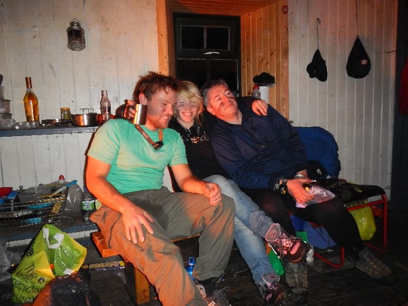
 ... and everyone was bantering away, carving pumpkins, making food, jumping into the loch and/or dressing up as the male reproductive organ. Words fail to describe the following scene...
Anyway what happens in the bothy stays in the bothy. I had pitched my tent outside and it rained all night and strong gusts were working on the tent. We woke up to a cold morning with snow capped hills and intense autumn colours.
 A strong Northerly was blowing but soon Beinn Bheoil protected us from the worst.
 Here is Robbie below snow capped Beinn Bheoil...
 ... and here are Katie and the other Robbie.
 Mile after mile along the Northern shore...
 ... to pass the Disney-like Ben Alder Lodge.
 One of the last views back the long loch with the Ben Alder complex on the right shore in the far distance.
HW

Monday 28 October 2013

Beinn Dearg four plus Seana Braigh

Every spring and autumn, Roger, Mike and I meet for some serious Munrobagging. This time we stayed in the Aultguish Inn bunkhouse (http://www.aultguishbunkhouse.co.uk/) which is the luxury version of a bunkhouse with en suite bathrooms and a large kitchen. We wanted to do the Beinn Dearg four but the forecast predicted 60 mph winds with gusts up to 80 mph after a lull in the morning and also both Roger and I had the remnants of a cold. My coughing was the alarm and we got up at 6 h to start walking from Inverlael at 7.40 h.
A landrover track follows the river Lael and generally there is easy walking to reach a saddle at the foot of Beinn Dearg and of two other Munros of the trip, Cona 'Mheall and Meall nan Ceapriachean. Here Roger and Mike nearly reach the end of the glen...
... and here they pass a lochain at the foot of Beinn Dearg.
Clouds came and went and during the ascent to Beinn Dearg we had at times views of Ullapool. The white dot on Loch Broom is the ferry from Ullapool to Stornoway on Lewis. The summer isles are further in the distance.
More to the North the Coigach peninsula with Stac Pollaidh and Suilven.
Finally the summit in good time and no gales yet.
We descended and crossed via a saddle over towards Cona 'Mheall. To the East the winter climbing cliffs that line Coire Ghranda.
Here is Mike on the ascent with Beinn Dearg behind...
... and here he is approaching the summit of Cona 'Mheall.
The landscape towards the North is remote.
A brief rest at the Cairn.
We then went over Meall nan Capraichean - all these Munros are close together - and here Mike crosses a line of white Quartz.
On the ascent to Eilidh nan Clach Geala we talked to three guys from Dundee which we met the night before in the Aultguish bar. By that time Seana Braigh entered one of our sentences...
... and at the Cairn, reached in good time and with still no bad weather in sight, we agreed to add Seana Braigh which is seen just to the left of Roger's head in the distance.
The walking was not quite as easy as anticipated and the wind picked up and was funnelled to reach high speed just before we were turning Northwards to reach first the top and then the main summit of the Old Height, as the translation of Seana Braigh goes. I had loved the remoteness the first time I did it and I loved it this time. One of my favourite hills with a dramatic corrie.
By now we had done some serious mileage and it was a seriously long way back to Inverlael, our starting point. We pushed on as walking in daylight is easier than walking at night. At 18 h it got dark, rainy and increasingly boggy. Mike had new pants which he hoped were waterproof (you guess whether they were) and had forgotten his head torch and so he practiced the art of semi-blind bogwalking. I did the Cairngorm winter climber trick of going visceral, just allowing the muscle diesel to tucker along whilst not thinking. Here a nocturnal crossing of a stream in the rain still many miles from Inverlael.
In the end my GPS watch said that we had done more than 36 km and no, we did not watch 'Whisky Galore' and no, we did not drink any Ardbeg. Also my heels were shredded as I was wearing new boots (some never learn) but after a good sleep my cold was better and here is our finisher photo in front of the Aultguish. The bunkhouse is on the right.  
HW

Monday 30 September 2013

The Tay from Perth to Broughty Ferry

The river Tay is the longest river in Scotland. It originates on the slopes of Ben Lui to reach loch Tay and from there it flows via Aberfeldy and Dunkeld to Perth. Here it slows and soon opens up to reach the North Sea to the East of Dundee. Last Wednesday it looked as if the weather and tide times were good enough for paddling from Perth to Broughty Ferry on Saturday and Phil Butler e-mailed plenty of tips. Soon Dave, Katie, Phil, Mark, Stuart, Gordon, Ana and myself joined the team and we met Saturday at 8.30 h at a slipway near the railway bridge. Here is the route...
... and here we are getting ready for the launch just after 9 am which was two hours before high tide at Perth. Two hours before high tide is a good time to start. 
 Here is Mark in his 'Amastra' waiting for everyone to enter the water. 
No wind and as a result the Tay was mirror-like for the first few miles. We made good progress especially after high tide which was at 11:02 h at Perth... 
... to reach Newburgh just before noon for the first break. We did not hang about as we knew that we could now ride the tide for 2-3 hours.  
 Here we set off again...
... and soon the fog lifted and some blue was visible in the sky. Also a weak Easterly started to blow and slow us down. 
 The second, brief stop was at Balmerino which was roughly 2/3rd of the way. 
After that we could see the two Dundee bridges. Here is Dave crossing the car bridge... 
... and here are Stuart and Ana paddling at a good pace after the bridges.  
Low tide Dundee was at 15.30 h and as it was a neap tide it only slowed us down a little. Last week an oil rig had moored in Dundee for an overhaul. 
 Here is Ana approaching it... 
 ... and here she is passing it. We were a bit close and a guy in a speedboat came and kept us away.
For me the paddler of the day was Stuart who thanks to an improved paddling technique (thanks to all our coaches, you have done a great job!) and thanks to plenty of kayak mileage had no problem completing the trip. Here, he is near Broughty Ferry castle... 
 ... and here is Ana approaching the beach after the castle. 
Mark had a GPS and it showed that we had paddled 26 miles, a full Marathon. A fantastic day for a great team of experienced paddlers and novices who have accumulated some kayak mileage over the summer. 
Finally the team photo in Broughty Ferry!
Maybe an annual journey? 
HW

Monday 22 July 2013

Summer & the Summer Isles

Visiting the summer isles by kayak on a summer's day is one of the hundred things to do in life. On Friday Ana and I left Dundee for the Porth a Bhaigh Campsite on the Coigach Peninsula to the West of Ullapool to join a trip organised by Karin and Vanessa of the Tayside sea kayak club. Here the view from the campsite.
 On Saturday our group, led by Ian the Admiral, was heading for Priest Island. Here is Ana passing a narrowing between the mainland and Isle Ristol just after leaving the campsite. 
 We were heading for a stop on a beach on the uninhabited Tanera Beag (I think). 
After that over the sea towards Priest island with the hills of North West Scotland in the distance. We saw a shoal of dolphins in the distance. Two are seen to the left of our group in the distance. 
At around 13 h we landed on a Priest island for lunch. 

 We paddled around the island and then went back to Tanera Beag. Here is Ana on her way...
 ... and here we are under the much photographed arch.
 The wind was up and against us and we finished our 30 km journey against strong winds at times to reach our campsite...
 ... where Karin and Vanessa had organised a beach BBQ...
 ... which went on until early Sunday under a full moon. 
 The next day the whole flotilla went North around the red sandstone climbing cliffs at Reiff
 Here some climbers in action. There is tons to do and I wished I was able to join them for a few climbs.
 Further around the peninsula Suilven appeared in the distance. A hill that I have not done and is near the top of the 'must do' list. 
 Here it is zoomed in.
 Pushed forward by the wind and held back by all the features that needed to be explored we arrived on the sandy beach on the Northern side of the Coigach peninsula. Here is my new, yellow P&H Scorpio with the rest of the kayaks behind. 
 The team split and a smaller group went back the way we came whilst others already drove back to Dundee. Here is Giulio, paddling against wind and tide. 
We reached the campsite after another 30+km paddle and Dundee at 2 am on Monday after a long drive back. Long may the Caledonian summer last!
HW